Home . GPS . Download . Business . Partners . Contact . Family . AVL . Links . History . AsOnTV .
GPS Navigation with the GPS Software
Updated 1000 Monday 4th February 2008
Home . GPS . Download . Business . Partners . Contact . Family . AVL . Links . History . AsOnTV .
GPS Navigation with the GPS Software
Updated 1000 Monday 4th February 2008
 This page tells you about the GPS Navigation mode within GPSS.
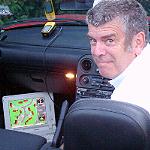
GPS Navigation mode is the most basic capability within GPSS and requires the use of a mobile PC, such as a Laptop, with a GPS plugged directly into it. For advice on getting a GPS, please click here.
If you download GPSS and run it on a PC which does NOT have a GPS, then GPSS will give a demonstration. The demonstration includes all the important features within GPSS, including navigation, Radio Direction Finding and AVL.
If you plug a GPS into your laptop running GPSS, it will work for real.
Most GPSS facilities are supported by free mapping from www.gpss.co.uk.
 First the bad news: turn-by-turn guidance is probably NOT available to you.
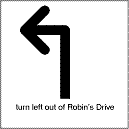
What is turn-by-turn guidance ? You see and hear examples in the GPSS demonstration:
"turn left out of Robin's drive"
Most GPS navigation products do provide this feature, and GPSS.EXE, the GPSS program, has supported it since the product was released in 1995.
However, turn-by-turn guidance requires very detailed and accurate mapping for the feature to be realized. Such mapping data is expensive, and certainly cannot be made freely available off a web site. Readers who have a hobby, academic or business interest in this are welcome to visit the LINKMAN page. Automatic Route Planning is closely connected with turn-by-turn guidance because of the data which is required. It is possible that this feature becomes a practical reality in the future, but "don't hold your breath" :-)
But now the good news: there are alternatives to turn-by-turn guidance: some may say better alternatives.
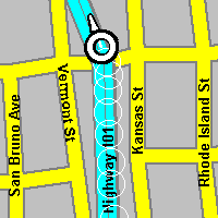
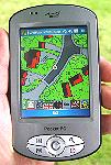
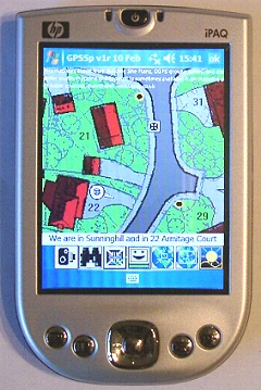
The most basic feature within GPSS is to show the GPS position on a map.
GPSS automatically scans all the maps it has and selects one for display, and puts the car icon on it.
GPSS also speaks your position, describing where you are:
"we are twenty five miles west of London and in Sunninghill"
 The data required to show your GPS position on a map, and speak the position, is freely
available as mapping for download off www.gpss.co.uk. At the time of writing this page the
mapping covered 162 countries and for the USA goes down to street level over all the USA.
The data required to show your GPS position on a map, and speak the position, is freely
available as mapping for download off www.gpss.co.uk. At the time of writing this page the
mapping covered 162 countries and for the USA goes down to street level over all the USA.
But you are not limited to the mapping data you can download off this web site: you may also use good quality displayed mapping of Microsoft CDs such as AutoRoute (for UK and Europe) and Trips (for USA and Canada). For details click here. See Maps from Images for more ways of adding maps to GPSS, including images from google earth and other web sites. Those who consider themselves sufficiently technical may wish to add their own GPSS mapping. For details click here.
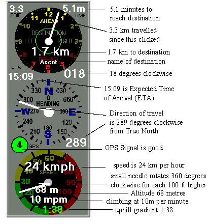
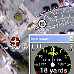
GPSS can display an instrument panel to guide you to a chosen destination.
GPSS also speaks this information:
"Destination Ascot, one point seven kilometres ahead at your one o'clock"
You can make GPSS use miles/yards, kilometres/metres or nautical miles, etc.
Other information displayed and spoken includes velocity:
"we are moving west at twenty seven kilometres per hour"
Expected Time of Arrival (ETA) :
"expected time of arrival is fifteen o nine in five point one minutes"
Altitude, rate of climb or descent:
"altitude sixty eight metres, climbing at ten metres per minute"
It even shows the slope of the hill if you are in a car :-)
e.g. ^1:38 means 1 in 38 uphill.
For tips on use of GPSS, such as choosing a destination, please visit the tips page.
 Voice recognition software, such as that on the
speech input page, will control GPSS.
Voice recognition software, such as that on the
speech input page, will control GPSS.
e.g. if the user asks, "where are we ?", then GPSS might reply with "we are twenty five miles west of London, in Sunninghill". The user demands, "be quiet !" - and then GPSS responds, "OK - I'll be quiet" - and then remains silent until spoken to (wouldn't it be nice if our wives and children also responded like this ? :-)
GPSS has been used with speech input since 1995 - but there is a simpler way: the keyboard.
Typing the single keystroke "W" means "where are we ?". Typing "Q" means "be quiet !". GPSS takes commands from the keyboard. Voice recognition software simply emulates the keyboard. The same principle is used if GPSS is used in applications where the user interacts with a touch screen, or some other input device. The user interface of GPSS can be configured to match the hardware - but support for this is not for end users.
You may read the full list of GPSS (keyboard/voice) commands in the GPSS.TXT online help here

If you run GPSS in it's UNREGISTERED state you will often see a little dog like Snoopy.
Snoopy will say, "this software is unregistered: why not buy a key code ?"
You can remove Snoopy by two methods:
What do you get for free when you run UNREGISTERED ?
 What do you get if you register with step 2 (Quiz) on the download page ?
For over 10 years GPSS has been providing facilities like those above on Laptop PCs. Now you can have the same facilities on much smaller platforms. For details see GPSS on Pocket PC based GPS and Smartphones.