Home . GPS . Download . Business . Partners . Contact . Family . AVL . Links . History . AsOnTV . Forum
GPS Software maps from images
Updated 1145 Tuesday 13th July 2010
GPSS user or Javascript expert ? Checkout the new
making maps
page.
Home . GPS . Download . Business . Partners . Contact . Family . AVL . Links . History . AsOnTV . Forum
GPS Software maps from images
Updated 1145 Tuesday 13th July 2010
GPSS user or Javascript expert ? Checkout the new
making maps
page.

 This page provides a little help to those of you who have already added the
mapping downloaded from gpss.co.uk and are now experimenting with GPSS maps
created from images from other websites, including aerial photos.
This page provides a little help to those of you who have already added the
mapping downloaded from gpss.co.uk and are now experimenting with GPSS maps
created from images from other websites, including aerial photos.
adding maps based upon aerial photos is not new: the image on the right is from the Exposiçăo Inforpor page, back in 2000. You may also want to take a look at the old Las Vegas page, set up shortly before we released the free street mapping covering all USA. What is new is the fact that, wherever you are in the World, you can probably download free aerial pictures of your home off the Net.
Please contact me for free support
using step 2 on the
download page, after you have GPSS responding
to the GPS (step 1). You can then help myself and many other enthusiasts
around the world find new sources of mapping and methods of adding maps to GPSS.
By now you should already have GPSS running on a laptop PC with the GPS and automatically displaying whatever free mapping is available from gpss.co.uk. For the USA and Japan this will be down to street level detail: for other countries the free mapping may be limited to major roads, rivers, towns, etc. Business users should beware: free access to software and mapping may not mean free distribution rights.
The technical details of adding mapping to GPSS are given on the addmaps page.
GPSS maps made using the methods described below should work on both the full Windows
version of GPSS, on laptop and desktop PCs, but also on
GPSS for Pocket PC and Smartphone.
Checkout this Italian site www.faureragani.it/mygps/getlatloneng.html for a convenient and useful access to Microsoft Virtual Earth. Thanks to Enrico in Sicily for telling me about it in April 2009.
This site displays lat/lon in decimal degrees, making it easier to work out the required GPSS .DES file. e.g. 40.5000 -73.8000 for somewhere near New York, USA.
It is easy to access and use directly from your Internet Browser, unlike Google Earth. The way I use it is to get the
map onto your screen, hit [Print Screen] to save into the clipboard before using another application
like Paint or Paintshop Pro to save the image with a suitable name (e.g. SFMAP.BMP) and reduced to
only 256 colours (or even 16 colours) non compressed BMP. Should then work with both GPSS and
GPSSppc without problems.
I then print the BMP and use a pen to scribble down details such as the size (e.g. 1024 x 768) and the two corner lat/lons by use of the web site.
Here is an example SFMAP.DES file for SFMAP.BMP :
San Fransisco Tollgate
SFMAP
LL, 1024, 768
37.80636 -122.4763, 0, 767
37.80748 -122.4746, 1023, 0
SANFRANC.WAW
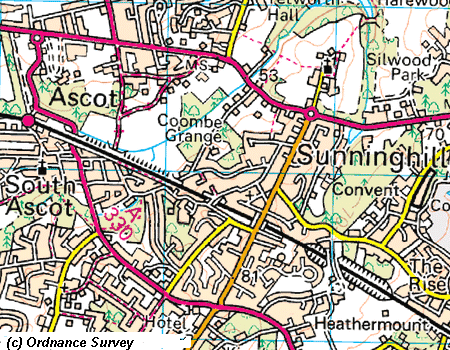
from Robin in 2010:It seems to be based on www.bing.com/maps which, if used full screen, gives great map images you can capture via the clipboard. It seems even UK Ordnance Survey maps here have been rotated to align with WGS84 lat/lon - as needed by GPSS/GPSSppc. You can find the south-west and north-east corners of your map image by using google earth or the Italian site above. The sample of OS mapping on the right, from www.bing.com/maps, is within the Ascot-Sunninghill area covered by the OSAG agreement.
In recent years, a good source of mapping, satellite and aerial photograph images is earth.google.com where you can download viewing software which has the advantage of switching on a lat/lon grid. Checkout "adding maps from earth.google.com" further below on this page.
Also checkout maps.google.com as a source of mapping including satellite images. The main problem is finding out the simplest way of working out WGS84 lat/lons for two image corners.
One of the best online sources of UK Ordnance Survey mapping is www.streetmap.co.uk. Look at the Ascot area here.
 Click
here
to see how you can add UK mapping into GPSS from Getmapping PLC and their web site.
This includes free low resolution aerial photos and inexpensive higher resolution
photographs and detailed Ordnance Survey maps.
Click
here
to see how you can add UK mapping into GPSS from Getmapping PLC and their web site.
This includes free low resolution aerial photos and inexpensive higher resolution
photographs and detailed Ordnance Survey maps.
These two simple examples should show you how to take free mapping at 1:25,000 and 1:50,000 scale, from the UK Ordnance Get-a-map™ . You may wish to read the terms of use on the OS site, but so long as this is for your own use, it appears to be OK. The map images you save will only be 400x400, but GPSS under full Windows on a Laptop will automatically stretch the map to fit the screen, and it is still usable. On a Pocket PC , with a much smaller screen, you should see no loss of detail.
Here are the steps to make a GPSS map using Ordnance Survey mapping aligned with OS grid:
Here are the two examples of DES files:
The first was SU933673.DES created for the most detailed 1:25,000 scale map in SU933673.BMP. This map is 2km across and so the second digit of grid reference changes by one. DES file format is explained on the addmaps page, but you should see what to do here:
Sunninghill at 1:25000
SU933673
GG, 400, 400
SU923663, 0, 399
SU943683, 399, 0
GPSS.WAW
This map can easily be compared with those in the GPSS Baseline, including ASCOT.BMP by using the map browsing tips.
The second example is for a 1:50,000 scale map which is 4km across. We could have used any 8 character name, but here we used 4U933673.DES :
Sunninghill at 1:50000
4U933673
GG, 400, 400
SU913653, 0, 399
SU953693, 399, 0
GPSS.WAW
 Those of you in the USA may wish to visit
terraserver.microsoft.com where you can
obtain aerial photos which can be used as GPSS maps. Details of this process appear under
"adding maps from terraserver" below.
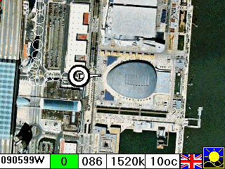
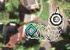
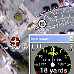
That fragment of an image on
the right is near the toll gate for the Golden Gate Bridge in San Francisco. Yes, that does appear
to be a light aircraft caught on camera :-)
Those of you in the USA may wish to visit
terraserver.microsoft.com where you can
obtain aerial photos which can be used as GPSS maps. Details of this process appear under
"adding maps from terraserver" below.
That fragment of an image on
the right is near the toll gate for the Golden Gate Bridge in San Francisco. Yes, that does appear
to be a light aircraft caught on camera :-)
You may prefer to use earth.google.com which seems much easier to use because of the support for lat/lon. See "adding maps from earth.google.com" below.
This is being written just a day after trying out terraserver.microsoft.com yesterday. I'm sure there are simpler methods than the one that I used, which involved taking lat/lon calibration points from the GPSS street mapping downloaded from www.gpss.co.uk/usa However, the notes below may be of some use to you. They are from an email to my friend Mihai in Romania, who drew my attention to earth.google.com above.
I added the USA map, but it took a long time getting lat/lon corners from my GPSS USA street maps.
There probably are simple rules, but they are not so simple. e.g. I went to that Terraserver link and used -122.47545 37.80717 for the Toll Gate on San Francisco Golden Gate bridge (yes they are other way round on their web site)
I selected the middle 800x600 image. It seems that their site changes the lat/lon e.g. to 37.80740 -122.47572 and this lat/lon is NOT in the middle of the image. It is in the middle for latitude, but centre is 45 degrees up from south-west corner.
The mapping that I used was in SANFRANC.EXE and www.gpss.co.uk/usa/37N122W.EXE
I took a very detailed image at 37.80740 -122.47572 and saved as TOLLGATE.BMP 800x600 pixels. My DES file was>>>>
Toll Gate for GGB
TOLLGATE
LL, 600, 400
37.80636 -122.4763, 0, 399
37.80748 -122.4746, 599, 0
SANFRANC.WAW
- but I'm sure this is not yet accurately calibrated.
Before that I did a much less detailed map SF1.BMP also 800x600 and using as the centre -122.46384 37.79491 my DES file was>>>>
SF from air
SF1
LL, 800, 600
37.77334 -122.5000, 0, 599
37.81600 -122.4276, 799, 0
SANFRANC.WAW
This map does seem to be accurately calibrated, matching the street maps well.
Most of these sites use decimal degrees for lat/lon. You can make GPSS display this format, rather than degrees and minutes, by use of Ctrl-U key ;-)
 Most of these words were written just a few minutes after seeing how easy it was
to add maps into GPSS from
earth.google.com
- thanks again to Mihai for pointing out that their search facility recognizes
lat/lons. It seems to recognize most formats, including a simple decimal
37.79491 -122.46384 - just as you might give it to GPSS :-)
Most of these words were written just a few minutes after seeing how easy it was
to add maps into GPSS from
earth.google.com
- thanks again to Mihai for pointing out that their search facility recognizes
lat/lons. It seems to recognize most formats, including a simple decimal
37.79491 -122.46384 - just as you might give it to GPSS :-)
It did not take long to set up the options including display of a lat/lon grid.
I then saved the image as TMP.JPG in my GPSS folder. tip: you may also wish to save the same image without the lat/lon lines. After calibration with GPSS you can then overwrite the BMP file by a "cleaner" one ;-)
I then double-clicked on TMP.JPG to fire up the Windows picture viewer, then saved as a BMP file, TMP.BMP.
I then followed the procedure explained in addmaps page, and edited MAPS.DIR with Notepad to insert TMP somewhere under THEWORLD.
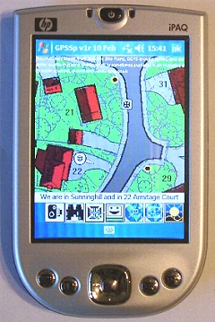
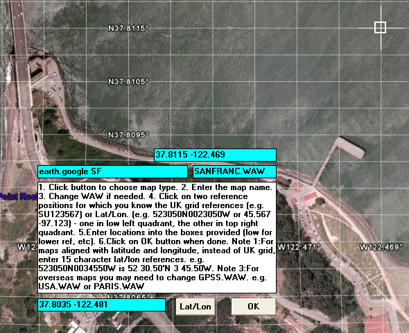
When I ran GPSS it put up the instructions as you see below. I clicked on two lat/lon intersections, one in low left corner, and one in the top right that you can see here.
I then filled in the corresponding lat/lon locations, and SANFRANC.WAW. Clicked OK, and ran GPSS again - the map checked out perfectly.
Don't forget that tip of using GPSS Ctrl-U ;-)
Beware of the google "hand" pointer: The problem is not the size of hand, but that at left (east) and bottom (south) edges it switches to the wrong lat/lon readout. I move the pointer carefully and note the west longitude or south latitude before it jumps to the wrong position.
You can save yourself time by switching google-earth to show lat/lon in decimal degrees, instead of degrees-minutes-seconds (where the seconds need dividing by 60 to get GPSS format). On google-earth menu use Tools-Options-View-Degrees.
Those doing step 1 and 2 (the quiz) on the download page now get an extra tip from me, pointing you to this page and giving you a lat/lon which google-earth will recognize based on that you put in the quiz form. If you had given me your lat/lon in the GPSS 15 character format: e.g. 512382N0003961W then the tip would include 51 23.82 N 0 39.61 W Put this into google-earth, zoom in, and you will see our house :-)
Here is another, perhaps simpler, method of making a GPSS map: Get the area you want on the google-earth screen; use a pencil and paper to write down the lat/lon of the mouse displayed by google-earth in the low left (south-west) and upper right (north-east) corners.
Taking care that you have not shifted the image, use File-Save Image, to save the image with a suitable name. e.g. MYMAP.JPG. You then convert this to a BMP file such as MYMAP.BMP (e.g. with Paint).
You will need those two corners of the image for the GPSS DES file (e.g. MYMAP.DES) These must be in one of the GPSS formats such as 15 character based on degrees and minutes (e.g. 512382N0003961W) or decimal degrees (e.g. 51.39700 -0.66017).
You can then use the procedure described earlier, using GPSS to make the MYMAP.DES file, or simply make it directly using Notepad, and information on DES file format on the addmaps page.
It is not too difficult to make the DES file yourself. Here is a worked example I did for my friend Angel in Mali, Africa: first I used google-earth to select a detailed image that included his house and local roads, etc. When I saved this, as ANGELSH.BMP, I saw that the image was 736x590 pixels.
I then used Notepad to make this DES file:
Angel's House
ANGELSH
LL, 736, 590
12.62000 -7.99100, 0, 589
12.62750 -7.98141, 735, 0
BAMAKO.WAW
As I mentioned earlier, the format of DES files is explained on the addmaps page, but here are some other tips:
The first line is the name of the map used by GPSS for display; the next line is the name of the map files: ANGELSH.BMP and ANGELSH.DES; the next line gives the map format and BMP image size; The next line is the south-west corner as lat/lon and display position (Y is zero at top); The last line is the WAW file, also explained on the addmaps page.
If I had used lat/lons in 15 character format, those two lines would look like this:
123720N0075946W, 0, 589
123765N0075888W, 735, 0
I'm sure Google and their mapping suppliers have no objection to you visiting google-earth and making maps for your own use. However, you should not distribute these maps to others without their permission - which is not likely to be practicable.
You can see our house by clicking here :-)
I used the PrtScn key to save the image into the clipboard before using Paintshop Pro to save it as a BMP file for GPSS. The DES file is made in the usual way, as above. I used google earth to find out the lat/lon corners, refering to a printout of the BMP image.