


Cliquez sur le drapeau français ci-dessus si vous préférez grenouilles et les escargots ŕ Roast Beef :-)
Home .
About .
GPS .
Downloads .
Business .
Partners .
Contact .
Family .
AVL .
Links .
History .
AsOnTV .
Holidays .
NHSCare.info .
Grumpy .
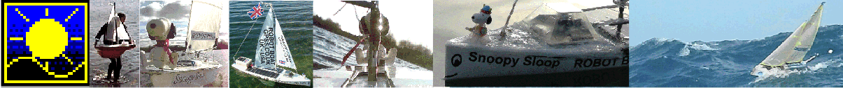
Snoopy


Snoopy's 2016 Trans-Atlantic Attempt
Updated 1845 BST Thursday 20th October 2016 UK time.
( What went wrong and why ? Planned work on 2017 Boat; Where will Snoopy land ? )
<<<<< Winds now and expected.... determine where Snoopy may drift and hit land.
Where did Snoopy go after 1004 BST 7th October, near Portland ? >>>>>
( Click on the pictures for the detail )


This "2016 Attempt" page tells the story of Snoopy's 2016 Attempt to cross the Atlantic in his little robot sailing boat.
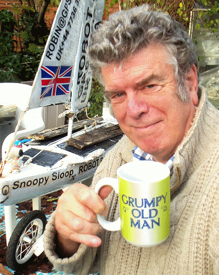
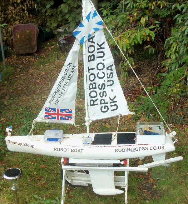
I'm Robin Lovelock, a grumpy old man, born in 1947, and that's me on the left, with Snoopy, sat on his boat used for the attempt.
Scroll down this page to see our story, told in pictures.
Play the Youtube video on the right to watch the launch, on Thursday 6th October, at 1115 BST UK time ( 1015 GMT/UT ).
For the "big picture" on Snoopy's Trans-Atlantic Robot Boat, see the
Snoopy page.
e.g. Earlier attempts each year from 2012, Newspaper, Radio and TV broadcasts.
You will see that Snoopy's 2016 boat has made many attempts, after it's first in 2013.
It's a tough little boat, and has survived, with little damage, after crash landings
on the Isle of Wight, Chesil Beach, and even outside a Brighton night club ! :-)
Snoopy is now lost, with his last SPOT position report being about a mile east of Portland, near Weymouth.
This was at 1004 BST ( 0904 GMT/UT) on Friday 7th October.
It seems Snoopy's unexpected path after launch can be explained by his rudder not being completely central,
causing him to steer to the right. We have experienced this before. This got worse as his mission progressed.

 What happened after Snoopy's last SPOT report ?
Robin's best guess is that Snoopy hit rocks on the east coast of Portland, causing
enough damage to let water into his box of electronics, including the SPOT tracker,
used to report his position.
Wind and tidal current then probably carried Snoopy south,
along the coast near Portland Bill, and then out to sea.
What happened after Snoopy's last SPOT report ?
Robin's best guess is that Snoopy hit rocks on the east coast of Portland, causing
enough damage to let water into his box of electronics, including the SPOT tracker,
used to report his position.
Wind and tidal current then probably carried Snoopy south,
along the coast near Portland Bill, and then out to sea.
With no steering,
Snoopy would simply drift downwind, expected to remain towards the south-west
for a few days. Snoopy's speed of drift downwind will depend on if his sails are up:
maybe 5% to 10% of windspeed if up, or nearer 1% if dismasted.
His path will go back and forth with the tidal current, but average progress will follow the wind.
e.g. maybe about 1 or 2 mph/knots if the wind blows at 15 mph or more, and his sails are up.
Winds are expected to blow towards the north by Friday 15th October, and shift to the normal Westerleys
at about Sunday 16th. Snoopy can then be expected to be blown back towards the French and English coasts.
Robin is confident,
from all other exploits, that Snoopy will still be floating.
Of course, Snoopy may have already been caught in rocks on either English or French coast.
What we need is a reliable report of a sighting, giving a rough time and location, however crude.
We can then update our best guess on where Snoopy is, based on the latest wind and tide.
If anyone sees Snoopy, please let us all know ! :-)
Thursday 6th October 2016: Snoopy's launch team .... Robin, Peter, and Dick ....

Who says Snoopy looks a bit weather-worn, after all those Atlantic Attempts in earlier years ? :-)

Robin hands Snoopy over to Dick, who has offered to risk life and limb launching Snoopy from the rocks ...

1115 BST ( 1015 GMT/UT ) Thursday 6th October: Snoopy is launched by Dick; Robin ready with his pole; Peter and Alex film the launch ...

Snoopy was soon difficult to see with the naked eye, just 30 minutes after launch ....

Dick and Robin chat to Alex, our new friend who we met on the beach. Alex sent us that fantastic launch video below.

Fantastic video of launch from Alex, who emailed Robin the Youtube link. Thanks Alex ! :-)
During our relaxed lunch at a sea front cafe, we watched Snoopy's progress via their Wifi.
We considered the train home, but opted for our cars.

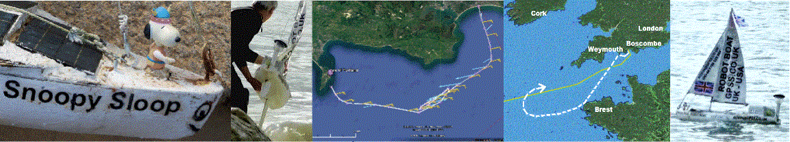
Peter's KML map, based on SPOT data, etc. Last SPOT position was 1004 BST Friday 7th October. Google Earth will display
RBAA16A1.KML.

Thursday night:
It should not be a problem, but it is certainly not what was expected.
It seems that, through an "accident of good fortune", of wind and tide directions,
and geometry, Snoopy managed to "cut the corner", skipping the "Channel" Waypoint,
to make faster progress. It seems Snoopy may be steering to the right,
probably due to the rudder not being exactly centered.
Friday morning:
He made little progress on Thursday night,
because the wind was not strong enough to fight the eastward tide.
Now Snoopy has the tide and wind behind him, until the tide turns eastward again at about 0800 BST Friday.
Let us hope Snoopy does not get too close to Portland Bill - he's done that before ! :-)

Snoopy was last seen on his SPOT tracker at 1004 BST, heading towards Church Ope Cove. A sighting or photo would be good !
Email received from Dick at 1805 Friday, before he headed back home from Portland:
Hi Robin,
Well no luck I'm afraid. I've walked the very rocky shoreline from the car park north for about 2-3 miles and examined the shoreline south of the car park for about a mile.
Pity we didn't get one more transmission just before he came a shore, or better still just after so a identify the spot... etc
"
Everyone: no taking risks please. I'm sure Snoopy will turn up one day, and at least it means we can switch to his much
lighter Boat 11, waiting in the wings for years ! :-)

Portland from the East, using Dick's
AA16PATH.KML on Google Earth. Later Wind & Tide analysis shows Snoopy may have travelled south, to left, towards Portland Bill.

 The rocky coastline is difficult to reach from land, to the south, as Dick discovered. You can use Dick's KML file with Google Earth,
to explore the area, or google images such as "east portland coast". I found this one of Cheyne House, near Freshwater Bay, that looks a nice place to stay.
Click on the image to enlarge it.
The rocky coastline is difficult to reach from land, to the south, as Dick discovered. You can use Dick's KML file with Google Earth,
to explore the area, or google images such as "east portland coast". I found this one of Cheyne House, near Freshwater Bay, that looks a nice place to stay.
Click on the image to enlarge it.
However, a search for Snoopy along that strip of coast, would be done much easier in a suitable boat in suitable weather and tide conditions.
Remember that the "shambles" is a notoriously dangerous area of strong tidal currents. More importantly, you could be wasting your time:
Robin's best bet is that Snoopy was carried out to sea. See the information below, on wind and tidal current.

What went wrong and why ? Steering errors to the right ? Rudder not exactly centred ?
 The nitty-gritty analysis of wind, tidal current, and Snoopy's behaviour with an offset rudder, have been moved onto the current
Blog6
page.
Google Earth analysis of Peter's KML file confirms that after launch, Snoopy was steering 17 degrees to the right, but by next morning,
this was nearer to 90 degrees. The last autopilot software change was 15th February 2015, to add the "Weymouth" Waypoint. Details of
software testing, including with Peter's software rig, are in
Blog4.
e.g. When east of "Weymouth", Snoopy should be aiming almost directly south for that waypoint, but this switches to "Prawle",
to the South-West.
This "Blog4" also includes detail about Snoopy's rudder servo linkage: look at the work in January 2015.
That servo "lever arm" should be held by an allen screw, clamped tightly against a flat, filed onto the rudder shaft.
The whole lot should have been fixed with Locktite, AFTER making sure the rudder is exactly centred, by testing on Bray Lake !
The nitty-gritty analysis of wind, tidal current, and Snoopy's behaviour with an offset rudder, have been moved onto the current
Blog6
page.
Google Earth analysis of Peter's KML file confirms that after launch, Snoopy was steering 17 degrees to the right, but by next morning,
this was nearer to 90 degrees. The last autopilot software change was 15th February 2015, to add the "Weymouth" Waypoint. Details of
software testing, including with Peter's software rig, are in
Blog4.
e.g. When east of "Weymouth", Snoopy should be aiming almost directly south for that waypoint, but this switches to "Prawle",
to the South-West.
This "Blog4" also includes detail about Snoopy's rudder servo linkage: look at the work in January 2015.
That servo "lever arm" should be held by an allen screw, clamped tightly against a flat, filed onto the rudder shaft.
The whole lot should have been fixed with Locktite, AFTER making sure the rudder is exactly centred, by testing on Bray Lake !


No Bray Lake Tests of Boat 10 since before the 2015 Atlantic Attempt !!!
I was horrified to discover, after looking at
Blog5,
that Snoopy's boat had not been tested on Bray Lake since the lastAtlantic Attempt in March 2015 !
It's hardly surprising that the rudder may have been a bit off-centre !
Looking further back in time, in
Blog4, shows weeks of 24/7 reliability testing on Bray Lake, in February and March 2015.
Click on that picture to enlarge it.
The last "Bray Lake Tests" were in February 2015, and show tendency to steer to the right. It seems it was never corrected !
My "Blog" pages are my "Engineering Notebooks", akin to what I was taught to use as a young engineering apprentice,
working in a laboratory for the first time, in the early 1960s. The difference of doing it online is that lots
of people can look over your shoulder and see where you made mistakes ! :-)
What would we do differently next time ? ... Next year's Boat 11 ...
The following is taken directly from the
Design
page, where it has been for some time.
Perhaps I should add "5) do Bray Lake Tests to check the rudder is central" ! :-)
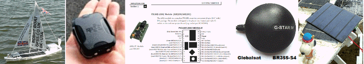
There is a lot I would not change in next year's Boat. e.g. 1.2 metre long Marblehead hull with IOM #3 Storm sails;
GPS-Only Autopilot, based on Picaxe computer and Globalsat BR355 GPS.
I may experiment with new ideas, such as power switching, compass steering, and wind direction sensors - but they
are only adopted after many months, or even years, of prototyping then thorough testing. However, I've added this
section, so you don't miss important future changes, mostly based on the discovery of better products.
In short they are: 1) Use of SPOT Trace, instead of a modified SPOT Messenger;
2) Use of the Picaxe 28X2 Computer, instead of the Picaxe 08M2: more memory and comes assembled;
3) Use of the Globalsat BR355-S2 GPS, including applying a firmware patch, and configuring
it with Static Navigation off, and only $GPRMC sentences;
4) Fewer but better solar panels.
You will see these products discussed in more detail, later on this "Design" page and linked pages.
The pictures should help you find the relevant sections.
Where is Snoopy now ? We need a visual sighting, or even a photo ! :-)

France is only 100 nautical miles downwind ! :-)
While we wait for any really useful information, such as a visual sighting of Snoopy, we can speculate
on where he might go in the days ahead....
The picture on the right is from Robin's old DRIFT model, originally used on GPS Bottles projects, years ago,
and last used on the
American Toy Boat page in March 2016. It needed the right tidal current and wind data
plugged into it. e.g. tidal current maximums between 1.2 and 1.5 knots. e.g. Winds 15mph from North East rising to 25mph
from East-South-East by Wednesday. Wind predictions are taken roughly from Ventusky
This gives a rough guess on where Snoopy might reach
by Wednesday 12th October, or earlier.
The white track is of a bottle, half submerged, drifting with the tide and surface water at about 3% of wind speed. The blue track
is at 5% - something catching the wind a little. The green is 10% - perhaps Snoopy with sails up,but with rudder hard over,
drifting in circles. Yellow and purple are 15% and 20% - sails up but with rudder central - running with the wind.
There are LOTS of assumptions here. e.g. that Snoopy managed to get free of rocks. e.g. that Snoopy drifts downwind, with his sails still up,
and no steering by his autopilot, and the rudder to one side. We think they have broken by now anyway. If they were working at all, his path
would be more westward. But speculation is no substitute for observations ! :-)
Planned work on the 2017 Boat ...
Responding to a sighting of Snoopy will obviously take priority: we would re-run the DRIFT model to get a better guestimate of where he goes next.
If, by good fortune, he is rescued, we can decide what museum to put him in. One thing is for sure, it's time for Snoopy's boat 10 to retire,
and for Snoopy to sail Boat 11, that has been "waiting in the wings" for years :-)
Here is a list of things planned, and things we should not forget to do:
- Replace the faded Union Jack flag, needed to wind up Yanks :-)
- Add a navigation light. e.g. like that garden lamp in picture. e.g. at front or on pole at back.
- Have my Panasonic Camcorder fixed. Focus problem would hamper video records of Bray Lake Tests.
- Weigh Boat11 and confirm it has not let water in while in the garden. Attend to paintwork, etc.
- Choose the most suitable version of the Picaxe 28X2 based Autopilot software.
- Investigate minor "tweaks" to steering logic that might improve steering accuracy.
- Put this in Boat 11 and start Bray Lake Tests - watching particularly for rudder offset problems.
- Investigate the ability of the Globalsat BR355-S2 to retain settings after a prelonged power failure.
If this is a problem, investigate making the Autopilot Software load the settings on startup.
- Assemble the duplicated Boat11 Solar power system. i.e. increase the two new panels to four or more.
- Extensive testing of the new 28X2 Autopilot Software, including methods used before.
e.g. Bray Lake Tests, Peter's Software Rig, Code Reviews, "Pub Tests", etc, etc.
- Investigate best power solution for the SPOT Trace. e.g. soldering wires into case, or use of USB socket.
- Investigate a work-around for SPOT Trace not reporting in very calm conditions - important for Bray Lake 24/7 tests.
Might be important at sea, under rare calm conditions. e.g. experienced years ago on GPS Bottles project in Channel.
- Build rudder linkage on Boat 11 same as that on Boat 10. i.e. use of two Z-links clamped together.
- Use something like the "finger of a rubber glove" to stop water entering up the rudder post.
- BRAY LAKE TESTS to make sure rudder is exactly correct, before applying Locktite. Repeat these tests often.
- Install SPOT Trace into Boat 11 in the waterproof box at the back.
- Bray Lake 24/7 Tests to check reliability, before Boat 11 is considered ready for it's next attempt.
- Consider alternatives of exact Boscombe launch spot and launch method. e.g. trolley into the water.
- Wait for the weather launch window. Fantastic if we get conditions as good as those in October 2016 !
If anyone thinks of something else, please email me :-)
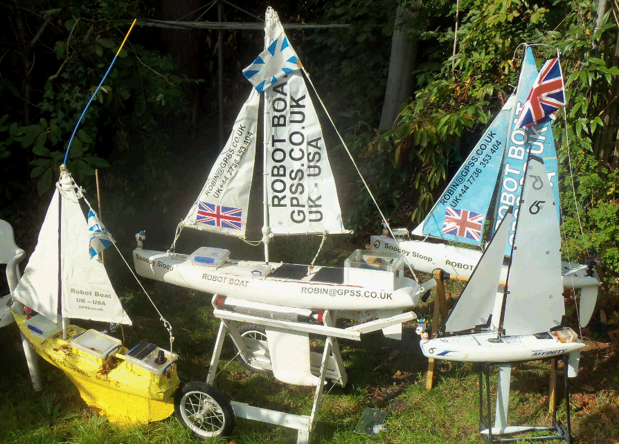
Below are Snoopy's boats, all fitted with experimental Autopilots. From Left to right: Boat6, Boat11, Eric's IOM Boat12, and little "Affinity".
Much of the above has been copied into the more detailed
Blog6
page, and can be replaced by any more news about Snoopy.
Who is visiting this page ?
How the web counters work - or don't work - is explained near the bottom of the
Snoopy page. Times are accurate but location is often not.

© 1991-2016 Robin Lovelock. Please credit www.gpss.co.uk if you use material from any of these pages. Thankyou.